Location, Location, Location
When I think of what makes an interesting-looking city, architecture is really only part of it. I think that an interesting landscape, particularly hills and rivers can be just as important as interesting buildings in making a city distinctive, so it only makes sense that I would try to find an interesting piece of virginal virtual wilderness to deforest and pave over for my new city.
New York has got just about every kind of body of water you can think of (ocean, harbor, river, sound, lake, canal, etc.), it’s a little shy on hills. As a result, I’d like to site Babble/On somewhere with a lot of rugged terrain, like Grenada, Spain or Hong Kong. I though about just trying to find some existing survey data from the web, but I think more and more that I’ll make my own landscape. Since this has been on my mind from the beginning and it seems a necessary early step in this project, I thought I might try to design a piece of landscape in CAD and render it in 3D, just to see how it would work. I decided to make a tiny little Edgar Rice Burroughs-style volcanic island about 250 feet in diameter that would jut up an almost equal distance into the sky.
There seem to be a lot of sophisticated ways to make a complex 3D surface (as opposed to something relatively simple like a wall or a sphere), most of which seem to involve creating a mesh in which the user specifies each junction point. However, all of this looks way beyond my skill level at this point and I wanted a faster solution, so I had this idea that I could draw a topographic map and then somehow connect the topo lines.
In case you’re not familiar with the concept, a topographic map is one in which a regular map of an area is overdrawn with lines such that every point on each line is the same elevation, the lines are spaced at regular intervals of elevation, and the lines are all labeled with their elevation. My little island doesn’t have a map because it doesn’t exist and I can’t draw, and I didn’t label the lines because I didn’t want to mess with it (but fyi, they’re at 10 ft. height intervals), but here’s a screenshot of the island in plan view.

After I drew the topo lines, the next step was to give each line actual elevation, to effectively lift it up off the map to the height it represented. This is actually really simple to do in CAD, if you set your layers up properly it just requires a few mouse clicks and typing in the new elevation for each line. What I had when I finished that is the picture below, although this time the island is shown as an elevation (view from the side).

You might get a better feel for how these fit together with this 3/4 view, which is the one I used to make a surface that would connect the topo lines.

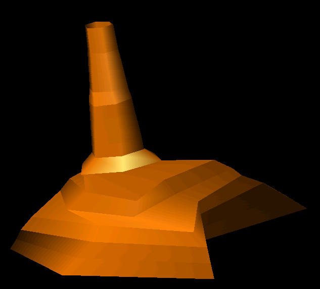
And this last shot is the wireframe above with the surface covering it, in a pleasant brown color that I hope makes it look like it’s made of rock. Not exactly a place to build a luxury condo, but it’s a start.

New York has got just about every kind of body of water you can think of (ocean, harbor, river, sound, lake, canal, etc.), it’s a little shy on hills. As a result, I’d like to site Babble/On somewhere with a lot of rugged terrain, like Grenada, Spain or Hong Kong. I though about just trying to find some existing survey data from the web, but I think more and more that I’ll make my own landscape. Since this has been on my mind from the beginning and it seems a necessary early step in this project, I thought I might try to design a piece of landscape in CAD and render it in 3D, just to see how it would work. I decided to make a tiny little Edgar Rice Burroughs-style volcanic island about 250 feet in diameter that would jut up an almost equal distance into the sky.
There seem to be a lot of sophisticated ways to make a complex 3D surface (as opposed to something relatively simple like a wall or a sphere), most of which seem to involve creating a mesh in which the user specifies each junction point. However, all of this looks way beyond my skill level at this point and I wanted a faster solution, so I had this idea that I could draw a topographic map and then somehow connect the topo lines.
In case you’re not familiar with the concept, a topographic map is one in which a regular map of an area is overdrawn with lines such that every point on each line is the same elevation, the lines are spaced at regular intervals of elevation, and the lines are all labeled with their elevation. My little island doesn’t have a map because it doesn’t exist and I can’t draw, and I didn’t label the lines because I didn’t want to mess with it (but fyi, they’re at 10 ft. height intervals), but here’s a screenshot of the island in plan view.

After I drew the topo lines, the next step was to give each line actual elevation, to effectively lift it up off the map to the height it represented. This is actually really simple to do in CAD, if you set your layers up properly it just requires a few mouse clicks and typing in the new elevation for each line. What I had when I finished that is the picture below, although this time the island is shown as an elevation (view from the side).

You might get a better feel for how these fit together with this 3/4 view, which is the one I used to make a surface that would connect the topo lines.

And this last shot is the wireframe above with the surface covering it, in a pleasant brown color that I hope makes it look like it’s made of rock. Not exactly a place to build a luxury condo, but it’s a start.
posted by Arazu at
11:10 PM
![]()
![]()

5 Comments:
Neat! Why is the bay with the surface on it so much more angular and straight-liney than the wireframe bay?
By Anonymous, at 11:02 AM
That's what I'd like to know. I used a command called RULESURF that will automatically connect two curves with a simple surface. Unfortunately, when I did this for the topo lines it connected them as if they were much simpler contours made up of straight lines and angles. This might be a problem with the tool itself, or it might be just that a system variable is set to simplify these things to save on computer resources. I'll have to do some more investigating.
By Arazu, at 11:39 AM
Goodness, man. We can't build on that horrid little island, are you crazy? Can't we find one a little less steep, perhaps one that doesn't look like it was impaled by a paper towel roll?
I mean, the rendering is very cool, don't get me wrong, but I just think I'll have too much trouble selling vacation property here. Unless we invest in some snowmaking machines and create the craziest extreme skiing resort in the world, then we'd be talking.
By Anonymous, at 12:17 PM
Hey There great Web Site Arazu, great post on Location, Location, Location I have a great site to look at Search Engine Traffic, feel free to call anytime, thanks!
By Anonymous, at 9:22 AM
Hey There great Web Site Arazu, great post on Location, Location, Location I have a great site to look at Search Engine Optimization, feel free to call anytime, thanks!
By Anonymous, at 8:43 AM
Post a Comment
<< Home